katla
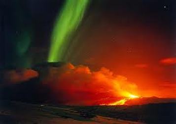
Katla is very active volcano it had twenty eruptions and they been documented.
Katla peak reaches 4,961 feet and the area is 230 square miles.
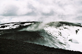
Katla is covered with 660-2,300 feet of ice.
katla is used as a female first name.
Katla is one of the largest volcanoes in Iceland. It is situated to the north of Vík í Mýrdal and to the east of the smaller glacier Eyjafjallajökull. Its peak reaches 1,512 metres (4,961 ft) and is partially covered by the Mýrdalsjökull glacier. The system has an area of 595 km2 (230 sq mi). The Eldgjá canyon is part of the same volcanic system.[3][4]
The caldera of the Katla volcano has a diameter of 10 km (6 mi) and is covered with 200–700 metres (660-2,300 ft) of ice. The volcano normally erupts every 40–80 years. The flood discharge at the peak of an eruption in 1755 has been estimated at 200,000–400,000 m3/s (7.1-14.1 million cu ft/sec), comparable to the combined average discharge of the Amazon, Mississippi, Nile, and Yangtze rivers (about 266,000 m3/s (9.4 million cu ft/sec)).
Katla is very active volcano it had twenty eruptions and they been documented.
Katla peak reaches 4,961 feet and the area is 230 square miles.
Katla is covered with 660-2,300 feet of ice.
katla is used as a female first name.
Katla is one of the largest volcanoes in Iceland. It is situated to the north of Vík í Mýrdal and to the east of the smaller glacier Eyjafjallajökull. Its peak reaches 1,512 metres (4,961 ft) and is partially covered by the Mýrdalsjökull glacier. The system has an area of 595 km2 (230 sq mi). The Eldgjá canyon is part of the same volcanic system.[3][4]
The caldera of the Katla volcano has a diameter of 10 km (6 mi) and is covered with 200–700 metres (660-2,300 ft) of ice. The volcano normally erupts every 40–80 years. The flood discharge at the peak of an eruption in 1755 has been estimated at 200,000–400,000 m3/s (7.1-14.1 million cu ft/sec), comparable to the combined average discharge of the Amazon, Mississippi, Nile, and Yangtze rivers (about 266,000 m3/s (9.4 million cu ft/sec)).
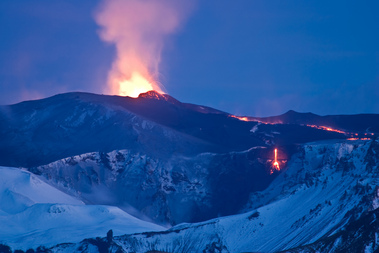
Hekla is a strato volcano in the south of Iceland.
Hekla height is 4,892 feet.
Hekla is one of Iceland most active volcano in Iceland.
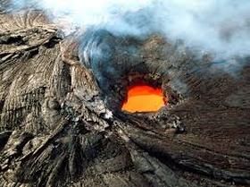
Hekla has produced on of the largest volumes of lava of any in the world in the last millennium 8 km3.
People in Iceland also call it hekla popper.
Hekla is part of a volcanic ridge, 40 kilometres (25 mi) long. The most active part of this ridge, a fissure about 5.5 km (3.4 mi) long named Heklugjá, is considered to be the volcano Hekla proper. Hekla looks rather like an overturned boat, with its keel being a series of craters, two of which are generally the most active.
The volcano's frequent large eruptions have covered much of Iceland with tephra and these layers can be used to date eruptions of Iceland's other volcanos. 10% of the tephra created in Iceland in the last thousand years has come from Hekla, amounting to 5 km3.
Hekla height is 4,892 feet.
Hekla is one of Iceland most active volcano in Iceland.
Hekla has produced on of the largest volumes of lava of any in the world in the last millennium 8 km3.
People in Iceland also call it hekla popper.
Hekla is part of a volcanic ridge, 40 kilometres (25 mi) long. The most active part of this ridge, a fissure about 5.5 km (3.4 mi) long named Heklugjá, is considered to be the volcano Hekla proper. Hekla looks rather like an overturned boat, with its keel being a series of craters, two of which are generally the most active.
The volcano's frequent large eruptions have covered much of Iceland with tephra and these layers can be used to date eruptions of Iceland's other volcanos. 10% of the tephra created in Iceland in the last thousand years has come from Hekla, amounting to 5 km3.
Askja
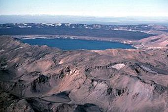
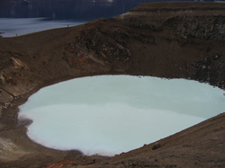
Askja is a large basaltic central volcano that forms the dyngjufjoll massif.It is truncated by three overlapping calderas.the largest of which is 8 km wide and may have been prodiced primarily from subglacialring fracture eruptions rather by subsidence.Lake Askja is the deepest lake in Iceland with a depth of more than 200 m. It was formed in 1875 when a powerful eruption occurred in the south of the caldera. Almost 2.5 cubic kilometres of volcanic material surged up from the vent in just a few hours. The process was similar to the sequence of events that originally created Askja. After the eruption, the magma chamber ceiling began to subside, eventually stopping almost 250 metres below its initial level. The depression filled with ground water and Lake Askja was formed.The name Askja refers to a complex of nested calderas within the surrounding Dyngjufjoll mountains, which rise to 1,510 m (4,954 ft) askja meaning box or caldera in contents.
Askja is a large basaltic central volcano that forms the dyngjufjoll massif.It is truncated by three overlapping calderas.the largest of which is 8 km wide and may have been prodiced primarily from subglacialring fracture eruptions rather by subsidence.Lake Askja is the deepest lake in Iceland with a depth of more than 200 m. It was formed in 1875 when a powerful eruption occurred in the south of the caldera. Almost 2.5 cubic kilometres of volcanic material surged up from the vent in just a few hours. The process was similar to the sequence of events that originally created Askja. After the eruption, the magma chamber ceiling began to subside, eventually stopping almost 250 metres below its initial level. The depression filled with ground water and Lake Askja was formed.The name Askja refers to a complex of nested calderas within the surrounding Dyngjufjoll mountains, which rise to 1,510 m (4,954 ft) askja meaning box or caldera in contents.